DUTY, HONOR, COURAGE, RESILIANCE
Talking Proud: Service & Sacrifice
Syria: A fractured state
Venture into the unfamiliar
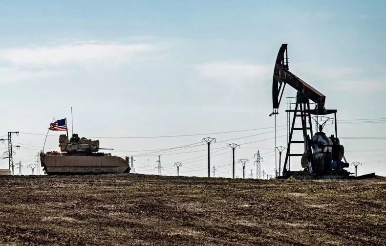
US troops in Syria: Protecting the oilfields
At this writing, the US has 2,000 troops in Syria. I believe US ground forces have deployed to two broad areas, which I have categorized as follows,
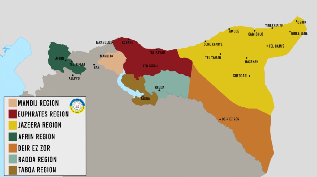
- Syria East: The entire northeast region of Syria east of the Euphrates River correlates with the locations of the biggest oilfields and the Kurdish Autonomous Administration of North and East Syria (AANES).
- Syria South: The base is in the southern Rif Dimashq Governorate, on the border with Jordan and Iraq.
Syria East
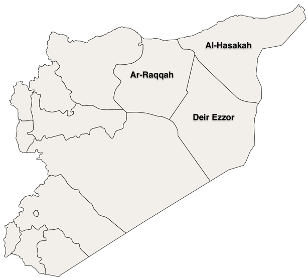
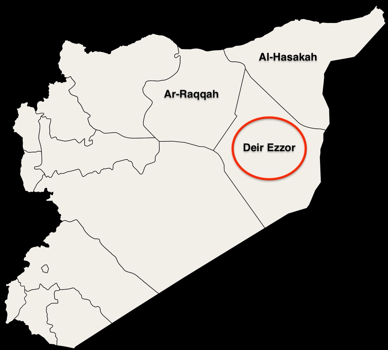
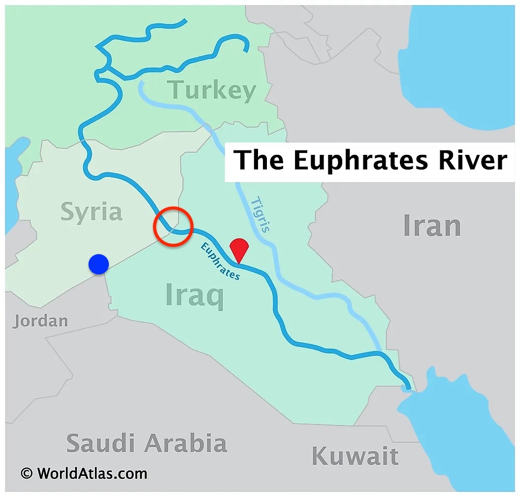
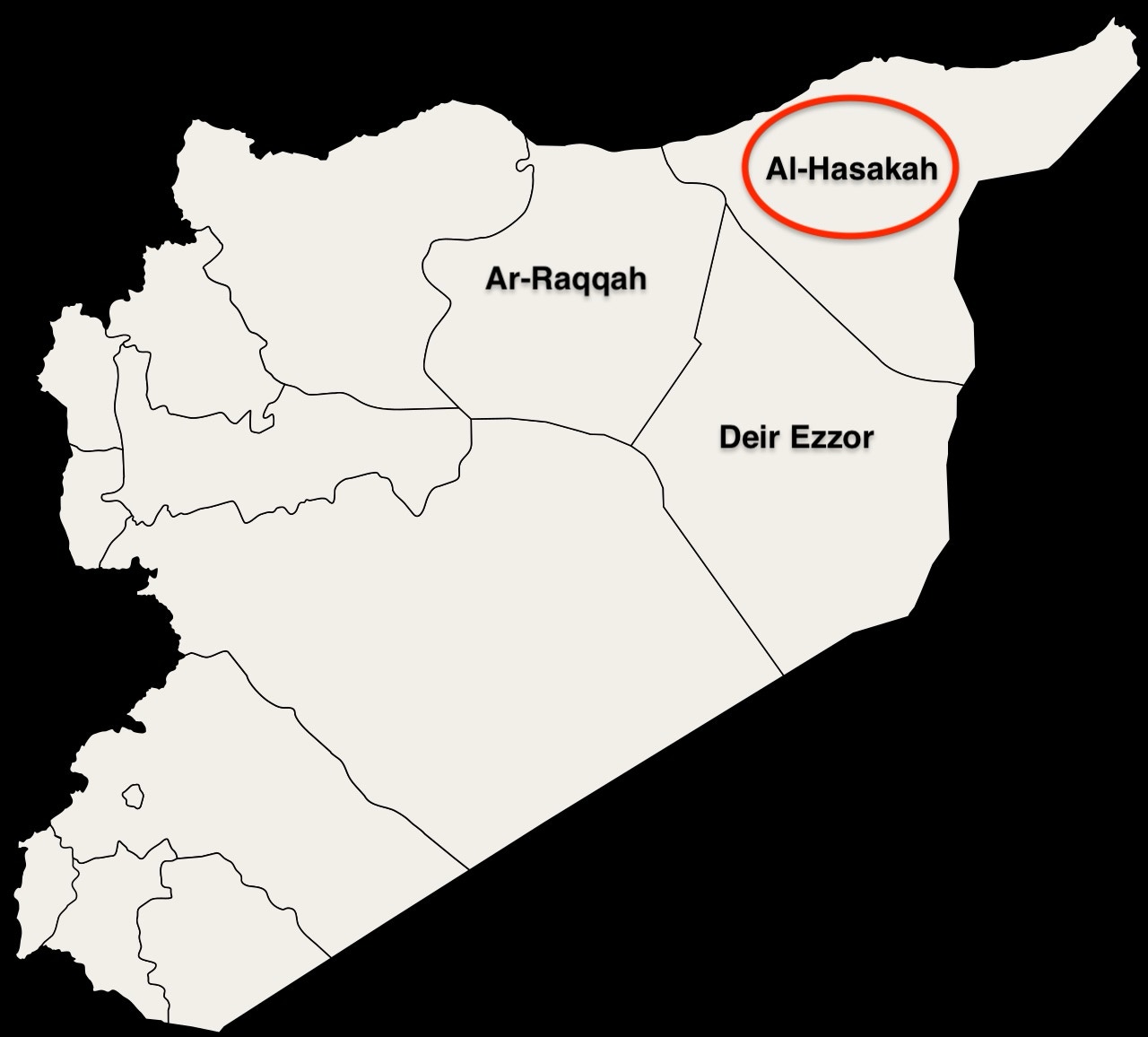
Syria East includes everything east of the Euphrates River. It consists of the Ar Raqqa, Deir Ezzor, and Hassakh Governorates of Syria.
Significantly, it correlates with the territory claimed by the Kurdish Autonomous Administration of North and East Syria (AANES), also known as Rojava, and covers Syria’s major oilfields.
Syria is not a major oil producer, but it does have sufficient oil to generate significant income for those who hold it. This has been at the core of US actions and those of its Kurdish allies. Syria’s important petroleum-producing locations are in Syria East.
IS took control of much of Syria East in 2013-2014, including the oil fields. Furthermore, IS controlled the markets for selling oil in Manbij and al-Bab, in the North but west of the Euphrates, and therefore, technically not in Syria East as I have defined it.
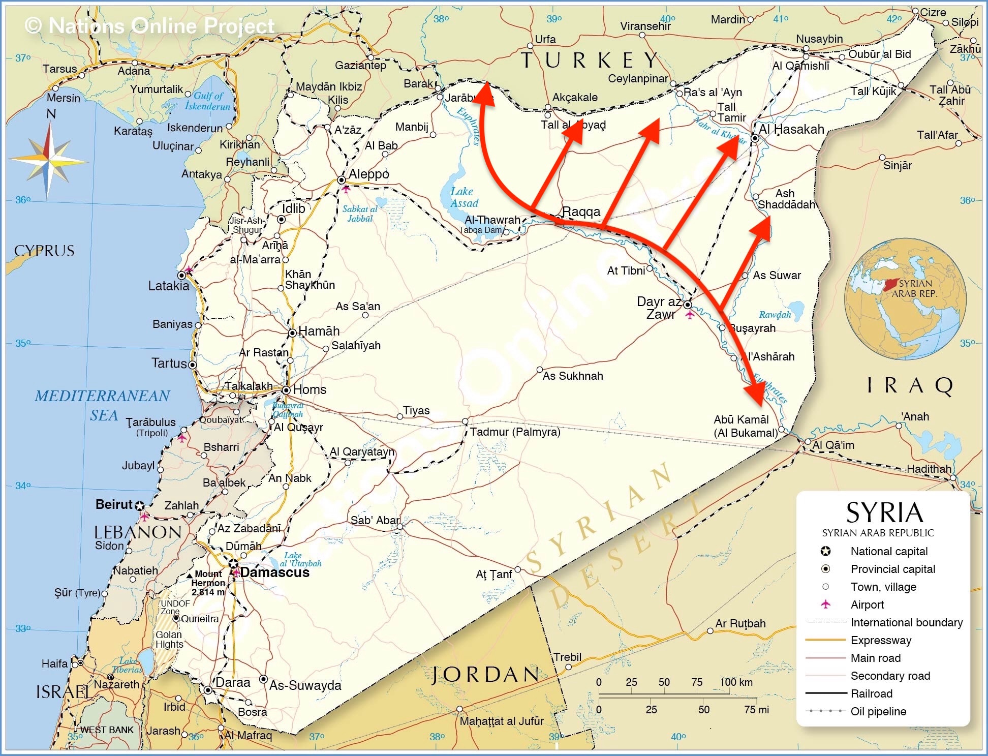
In response, the Combined Joint Task Force-Operation Inherent Resolve (CJTF-OIR) launched significant air attacks in September and October 2014 against IS oil operations in the vicinity of Ar Raqqah, Deir Ezzor, Al Hasakah, and Abu Kamal, in short, along the length of the Euphrates River Valley. The CJTF named its campaign “Operation Tidal Wave II,” mimicking Allied “Operation Tidal Wave” air attacks in German-held oil fields in Romania during WWII.
Recall that President Obama told Americans in 2014 that the US would degrade and ultimately destroy the IS. The US feared that IS would grow as a result of its access to oil revenues and that it would threaten the US homeland.
The Financial Times indicated that IS control of the oil fields was well-organized and top-down,
“The al-Omar fields were ‘the biggest draw’ … For now, in the Isis-controlled territory, the jihadis control the supply and there is no shortage of demand.”
A Pentagon spokesman said that in 2014, IS was earning up to $2 million per day from oil revenues, which enabled it to build and grow.
We then learned from Time Magazine in 2015 that a US Army Delta Force “killed Abu Sayyaf, known as ISIS’s ‘oil emir,’ during a nighttime raid into eastern Syria.” The special forces scarfed up extensive records, which opened the book on the IS oil production infrastructure. In short, US intelligence and the warfighters learned a great deal about how the ISIS oil system worked.
Starting in October 2015, the US stepped up its attacks against tanker trucks carrying oil to market, selling much of their oil to Turkey at bargain-basement prices. PBS reported ISIS was hauling in as much as $50 million a month.
CJTF was attacking the problem from the air, but that was insufficient to derail IS and its oil holdings. IS engineers were able to repair what was damaged by the air attacks. IS was able to keep the oil flowing. The CJTF had to adjust. It began to strike at targets that would take longer to repair. B-1 bombers and other allied warplanes in November 2015 struck hard at the Omar oil field, one of the two largest oil-production sites in all of Syria. The idea was to debilitate multiple major oil fields and refineries held by IS.
The New York Times said,
“Instead of putting the group’s oil-production capability out of action for days, the new goal is to knock out specific installations for six months to a year, the officials said. This involves targeting fuel oil separators and elements of pumping stations at sites in Islamic State-controlled areas of Deir el-Zour.”
In early 2016, Financial Times reported that IS was still benefitting from oil revenues and that “oil is still a major revenue stream for Isis's central leadership” despite the new air campaign against oil facilities. The CJTF needed a ground force of considerable size and capability to get in there, evict IS fighters, and take control of as many oilfields as they could. The focus would be on Syria East..
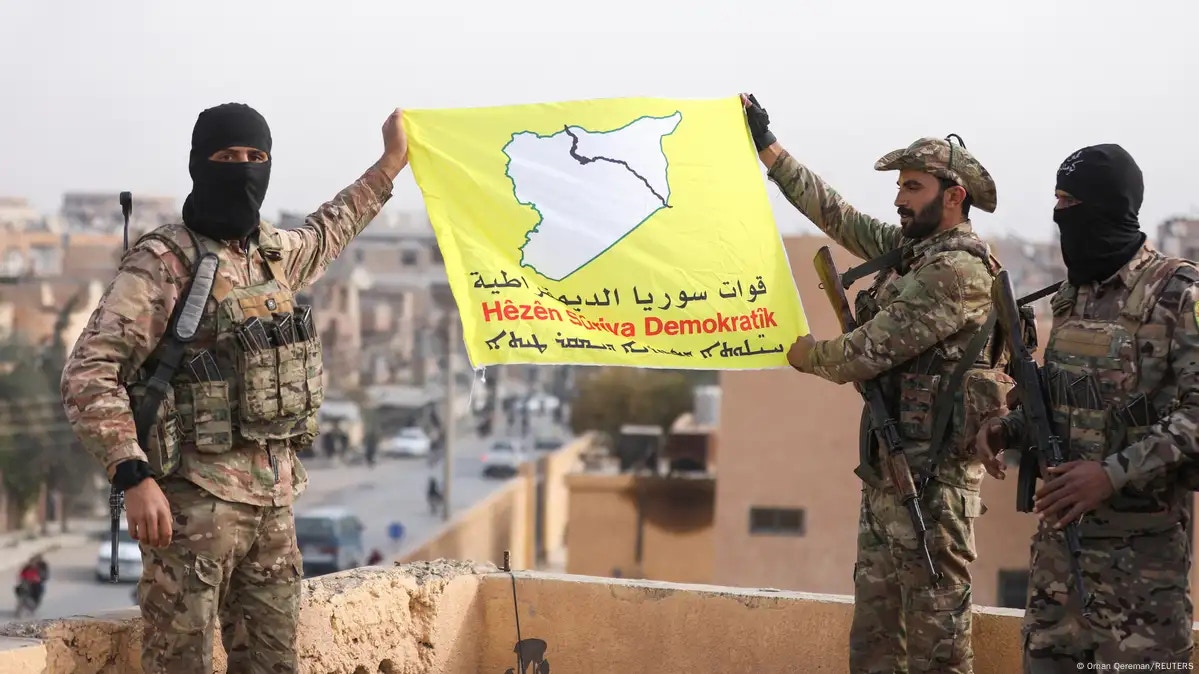
The US turned to the Kurds, specifically to the Syrian Democratic Forces (SDF), which was officially founded in late 2015 and was comprised mainly of Kurdish and Arab militias. Small militias joined and quit over time.
The SDF became the CJTF-OIR’s proxy ground force, and the CJTF has provided supporting air power.
Michael Knights and Wladimir van Wilgenburg said,
“When the U.S. military fights ‘by, with, and through’ a partner force, this refers to operations [that] are led by our partners, state or nonstate, with enabling support from the United States or U.S.-led coalitions, and through U.S. authorities and partner agreements.”
The US decided that the SDF was such a partner, a non-state partner, that men and women living in Syria were ready and able to take on IS.
In the minds of both the US and SDF, the mission to destroy IS demanded taking the oil fields located throughout Syria East, taking their attendant revenues away from IS, and using these revenues to support the SDF.
By January 2019, after several years of brutal combat, the territorial situation had developed where the SDF and its US partner controlled most of Syria East, including the southeastern town of al-Bukamal, located on the Iraqi border.
The territory the SDF occupied roughly correlated with the self-declared autonomous Kurdish region. CJTF provided air support and stationed over 500 troops on the ground to train and assist the SDF. These American troops did train SDF forces, but remember that the trainer often needs to fight with those being trained to see how well the training was working.
Journalists portrayed US boots on the ground as protecting and holding Syrian oilfields, inferring the US was benefitting financially. In 2019, Jonathan Rath Hoffman, Assistant to the Secretary of Defense for Public Affairs, reacted, telling reporters,
“The revenue from (Syrian oil fields) is not going to the U.S. (It) is going to the SDF.”
He emphasized that the goal was to prevent IS from having access to the oil fields and their revenues.
Fabrice Balanche, writing for the Washington Institute for Near East Policy, has said the US troops patrol roads near the oil fields “intensively, preventing Russian and Syrian forces from using roads outside their immediate area of influence.”
That’s the picture I have of the US ground force deployment in Syria East. US military ground forces operate throughout Syria East, in one way, shape, or form, with or without their SDF allies.
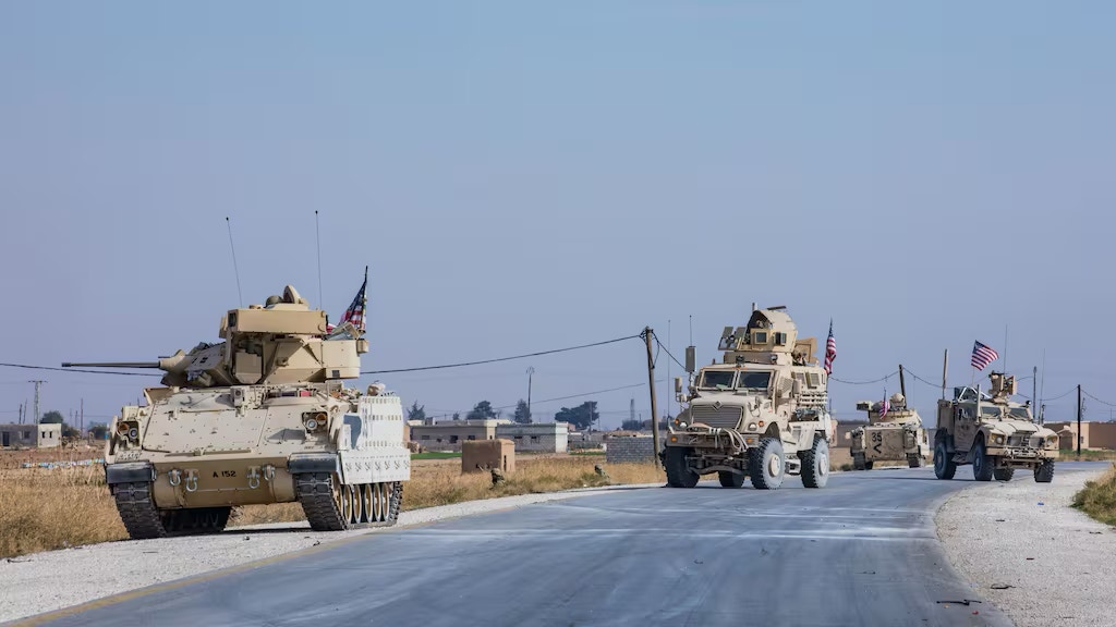
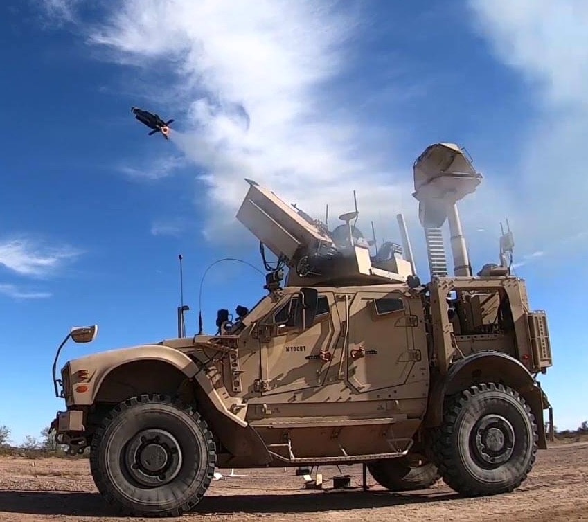
US ground forces are mobile and can, at times, be static. They might be in any place at any time and have varied strength throughout the entire region east of the Euphrates River Valley. They use various vehicles, including the M2A3 Bradley Fighting Vehicles, M-ATV armored trucks, and Mine-Resistant Ambush-Protected (MRAP) trucks.
They have air defense systems like the Coyote to counter drone and missile attacks. There has been scuttlebutt that the US has also deployed the Avenger air defense system. The troops have mortars and the High Mobile Artillery Rocket System (HIMARS) for force protection.
The problem for the US was that their active presence in Syria East attracted hostile gunfire and missile and rocket attacks. Carla Babb reported on November 17, 2023,
“Iranian-backed proxies have attacked U.S. forces in Iraq and Syria at least 150 times since President Joe Biden took office, two U.S. defense officials tell VOA. More than a third of those attacks have occurred in the last month, marking a clear surge in violence against U.S. forces in the region.”
Remarkably, US ground forces have not taken more casualties, which is truly remarkable. Most of the sites used by US ground forces are attacked regularly by IS, Iranian-backed proxies, the Syrian Army, and even the Turkish Army. No Americans have been killed while operating in Syria during the period 2011-2024. Attacks against them have injured quite a few US military members, however. Some have been evacuated with traumatic brain injuries.
I do not know where the US ground forces are positioned in Syria on any given day. Sadly, a way to track them is to read news reports about attacks against them at various locations.
I will highlight places in Syria East where they might be on any given day. A few of these are not oil-related but are worth noting.
Most locations are in areas of considerable military, social, cultural, and political turbulence.
I have no “inside scoop” on the bases I describe. I have pieced together reports I have found, many of which come from Near East press descriptions of attacks against US forces at these locations. I’ve attempted to create a credible picture.
I have included screenshots of Google Earth imagery to give you a sense of the bases used by US ground forces and their surrounding areas. I believe I have correctly identified them.
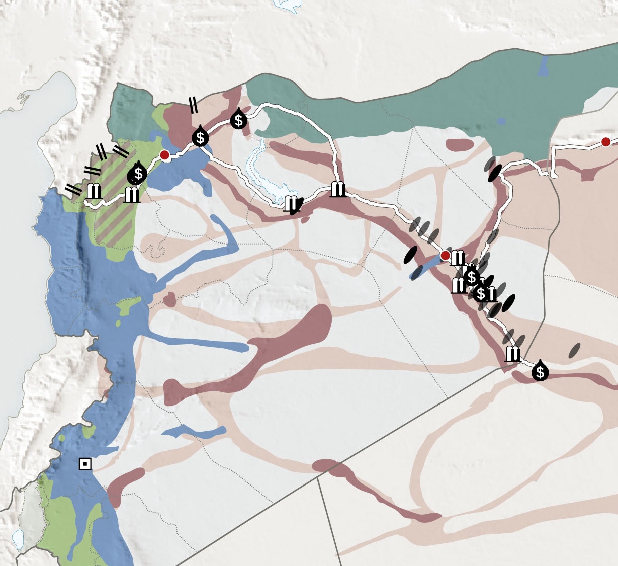
Deir Ezzor Governorate
US-SDF forces control most of the Deir Ezzor governorate, which extends from Raqqa to the far southeast border with Iraq at Al Bukamal. Syria's known oil reserves are mainly in the Deir Ezzor Governorate along the Euphrates. Several smaller fields are located in the center of the country.
The International Crisis Group calls this area the Middle Euphrates River Valley, Syria,
“The Euphrates marks a rough dividing line between forces backed by Iran and the U.S. that compete over territorial control. To the river’s east are territories controlled by the U.S.-backed Syrian Democratic Forces (SDF), while pro-regime, Iran-backed forces dominate the western banks.”
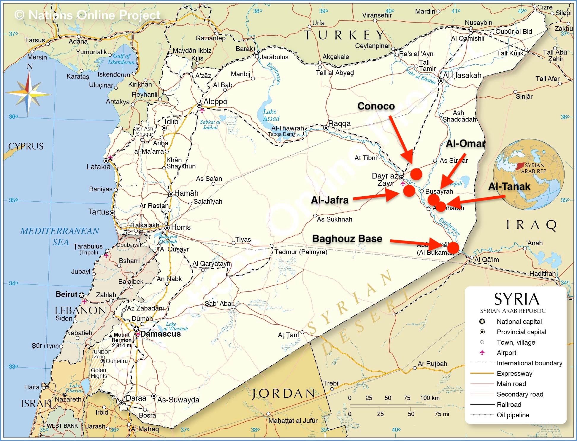
I’ll walk you down the Middle Euphrates from Deir Ezzor to Al Bukamal, highlighting some of the significant bases patrolled or used by US forces.
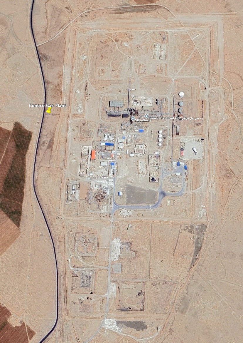
Mission Support Site Conoco (Koniko): About 10 miles east of Deir Ezzor City. US-SDF forces have controlled the Conoco Gas Plant since September 2017. It is also called Mission Support Site Euphrates. Lolita Baldor, AP, reported in January 2020 that “plant buildings and old homes have been turned into high-tech (military) operations centers and barracks.”
Opposing forces have attacked this site regularly with rockets, missiles, and drones. Stars & Stripes reported in November 2024 that the site “has become the front line for an Iranian proxy attempt to pressure U.S. forces to leave Syria altogether.” US ground forces have been in the fight.
The Battle of Conoco Fields of 2018 was grueling and involved pro-Assad fighters and Russian mercenaries. The pro-Assad forces employed tanks, artillery, mortars, and rockets. The USAF used F-22 and F-15E fighters, B-52 bombers, AC-130 gunships, drones, howitzers, and rocket artillery to defeat the opposing forces estimated to be 500-strong. The US claimed to have killed over 100 enemies, while it did not lose anyone, though the SDF lost one.
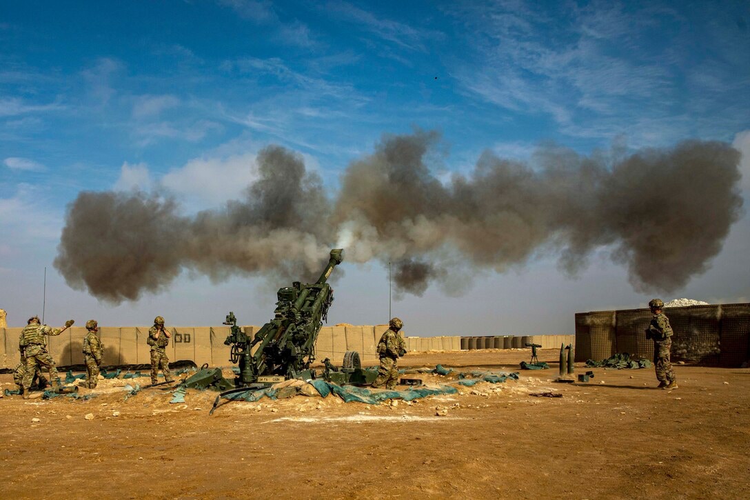
The US has countered with artillery strikes. The photo credited to Sgt. Julio Hernandez, USA, shows soldiers firing an M777 howitzer during an exercise at MSS Conoco. You get the idea. Holding the Conoco installation has not been a cakewalk.
Make no mistake: US ground forces always face combat situations here. It is a no-fooling-around assignment.
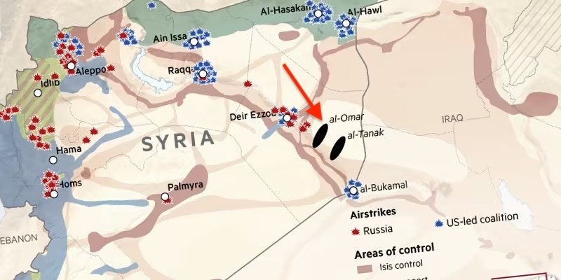
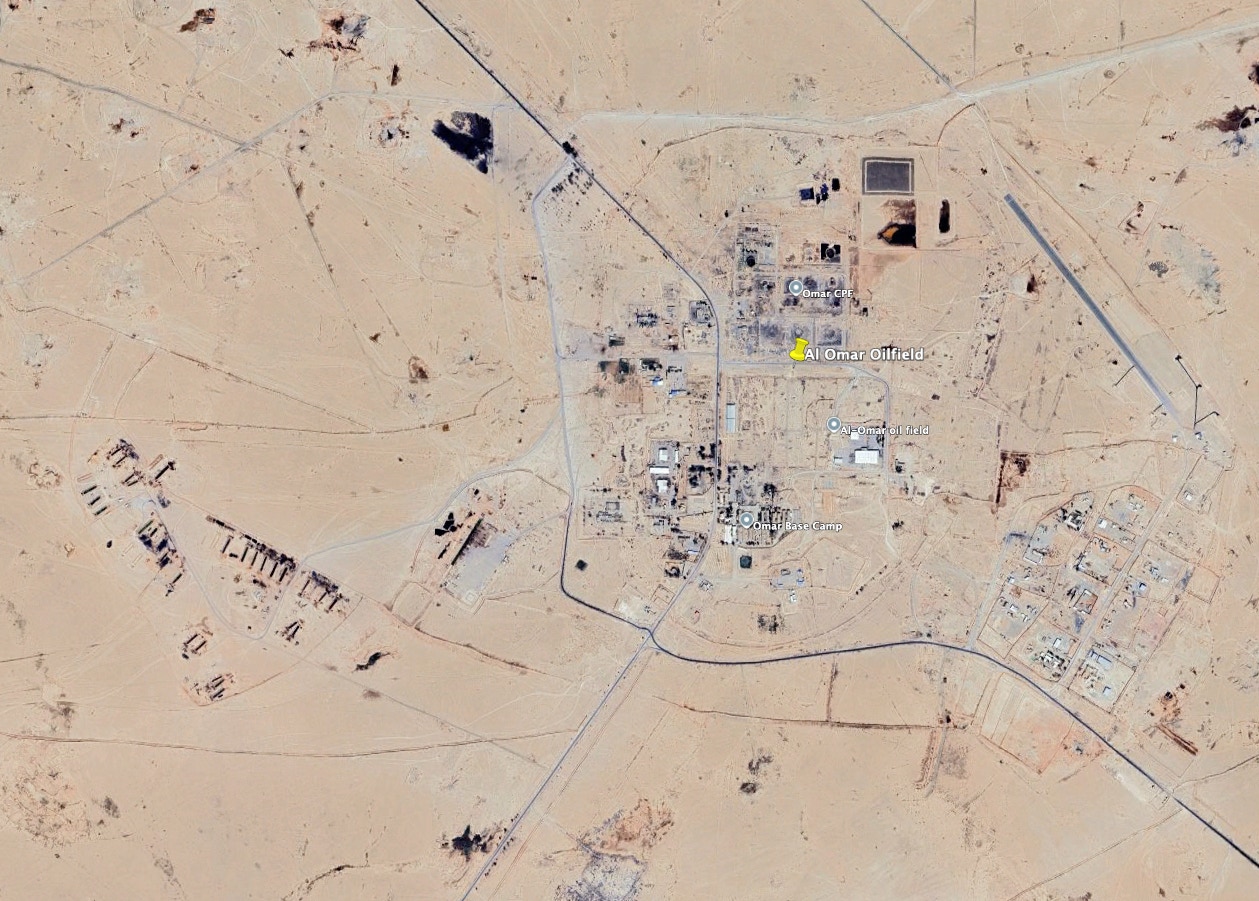
Al-Omar oilfield: US-SDF forces took control of the Al-Omar oil and gas field in October 2017 and have maintained control. The field is said to be Syria’s largest. It is about five to six miles east of the Euphrates River and about 31 miles southeast of Deir Ezzor.
Opposing forces constantly attack US forces here, employing missiles, drones, and rockets. I have seen reports saying “drone swarms” have been used against al-Omar. Enemy forces have also attacked tanker trucks with truck-mounted machine gun fire.
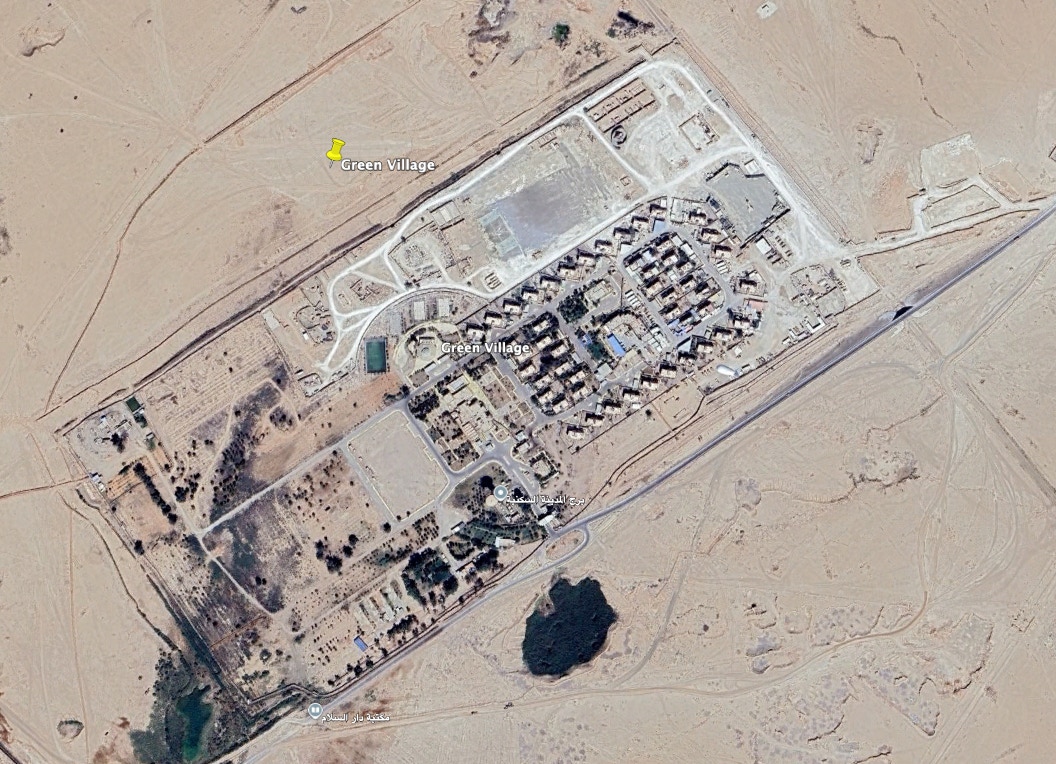
US Mission Support Site (MSS) Green Village at the Al Omar Oil Field: Green Village is about three miles southwest of the Al Omar oil field. Near East news reports say US military personnel are housed there.
If accurate, that makes sense, as the village is roughly halfway between Deir Ezzor City and Al Bukamal to the far southeast. It is also close to the Al Khabour River, which slants off to the northeast and is the location of key oilfields.
Al Jafra oilfield: IS took control of al Jafra on the west side of the Euphrates in April 2014, about 16 miles south of Deir Ezzor. That is unusual since most of the fields are on the east side. The US-SDF took it back in October 2017.
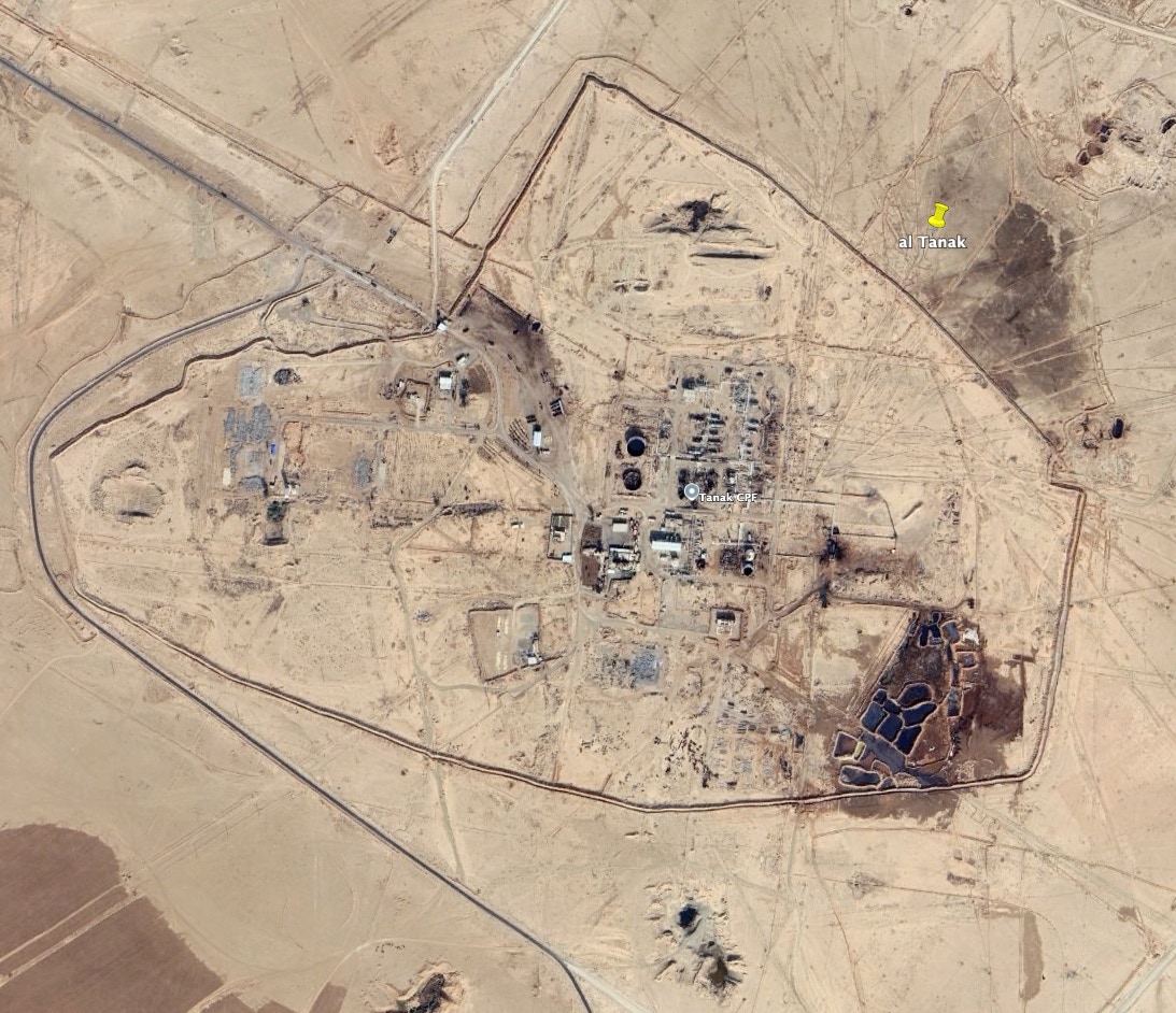
Al-Tanak oilfield: US-SDF forces captured the al-Tanak oil field in November 2017. It is said to be the second-largest oil field. It is 46 miles southeast of Deir Ezzor City and 18 miles southeast of Omar. IS took control of the field in February 2015. There are reports that HTS-aligned “Syrian tribal forces” took the field back in December 2024. I cannot confirm this.
Baghouz Base: It is a small base in the far southeast of Deir Ezzor Governorate, close to the Al-Bukamal border crossing with Iraq. It has traditionally been a crossover point for jihadist fighters between Syria and Iraq. The US-SDF took control of the al-Baghouz village in March 2019, the last IS stronghold in Syria. The battles were furious and involved US air attacks along with helicopter support. I’ll highlight the blue dot on the map marking the al-Tanf base in southern Syria, which I will address in the next section. I’ll note that it is about 140 miles southwest of the al-Bukamal border.
The Baghouz Base is about 80 miles of patrol distance from Conoco to Baghouz Base. That’s a stretch considering the roads, traffic on those roads, terrain, and the potential for being ambushed.
Hasakh Governorate
One is likely to hear a lot about the bases in the Hasakh Governorate as they are in far northeastern Syria, which has been a US-SDF stronghold. James Jeffrey, formerly the US Special Representative for Syria Engagement, saw a firm requirement for an American presence on the ground in this region,
“A U.S. ground presence in northeast Syria is vital for keeping ISIL under control, not only in that large area, but also throughout Syria … The U.S. government uses northeast Syria as its platform for intelligence collection and for raids against the Islamic State’s leadership in parts of Syria controlled by Assad. It also justifies the critical mission of controlling airspace … based on providing force protection to the troops on the ground below.”
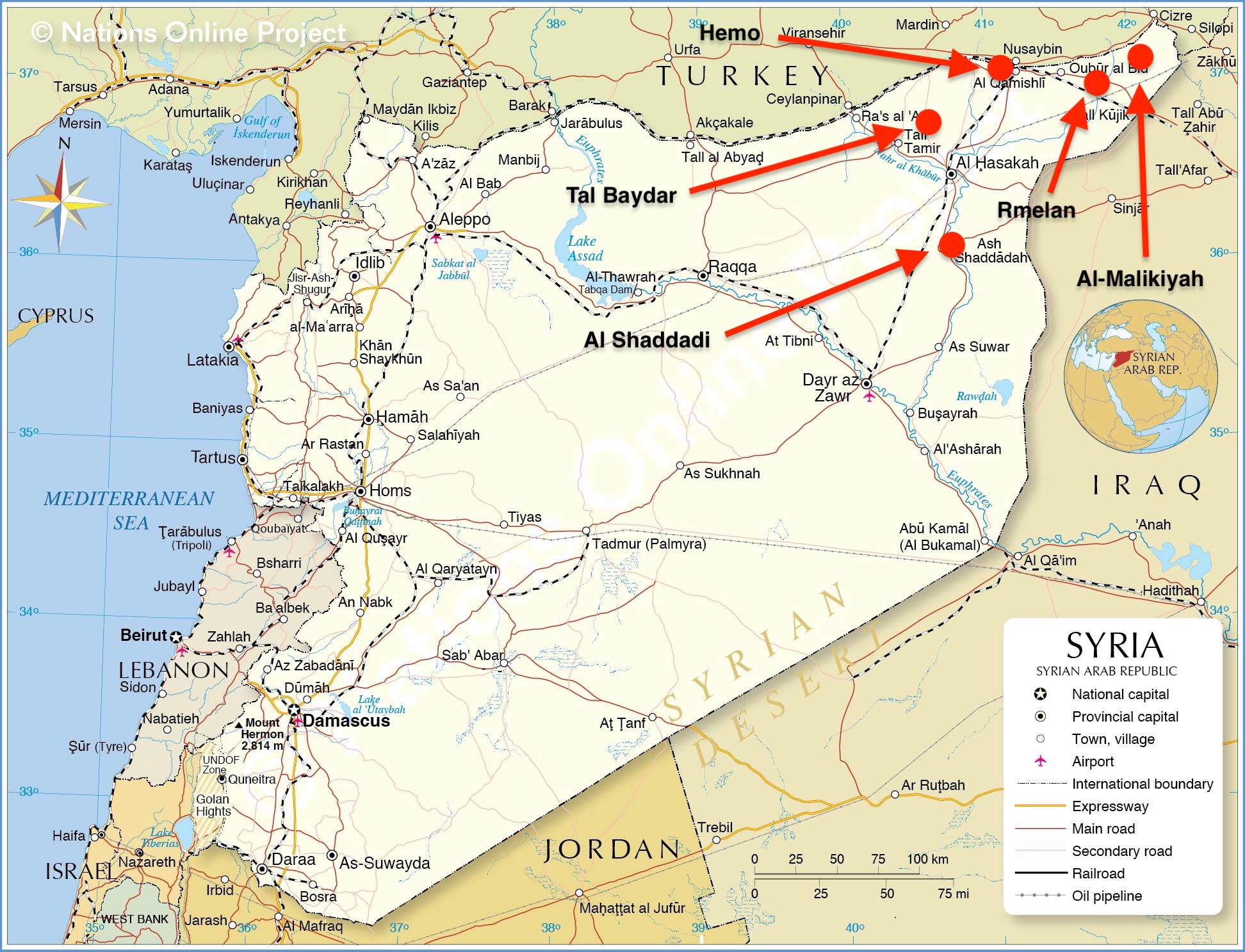
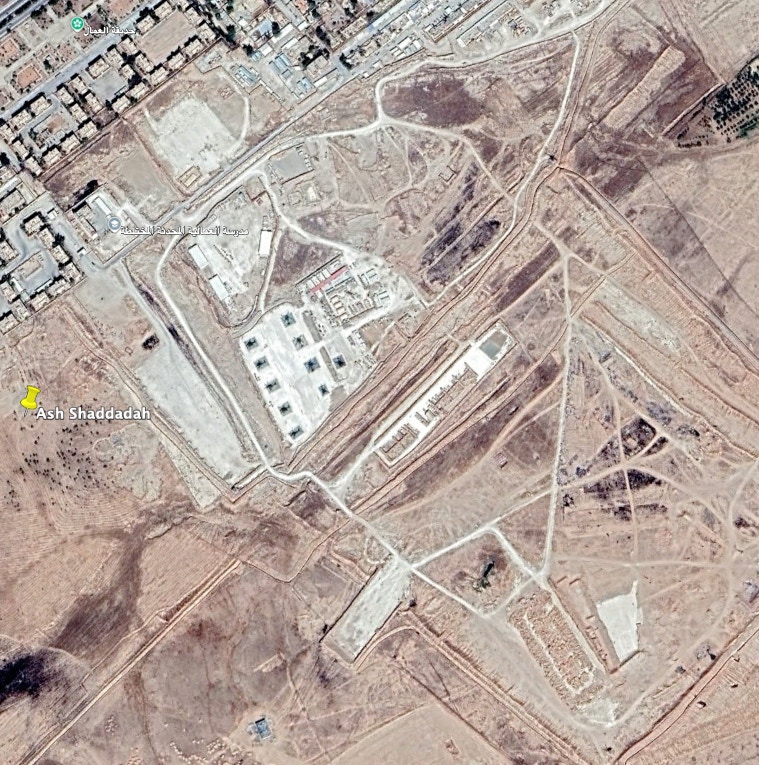
Patrol Base Al Shaddadi Base: US-SDF forces captured the city in February 2016. Wikipedia has called it a strategic city, probably because it was the last city in the southern Hasaka Governorate to be cleared of IS. The city is also roughly halfway down the Al Khabour River, flowing from Turkey to the Euphrates, about 60 miles north of where the Al Kabour meets the Euphrates.
A base of some sort is on the southeast side of the city. The imagery I have seen shows eight helicopter parking ramps there.
The Middle East Media Research Institute (MEMRI) reported in September 2019 that the Asl Shaddadi Base was “one of the largest American bases in Syria … It includes a camp for Marines as well as an airbase of eight attack helicopters, in addition to being a logistics base for U.S. troops and Kurdish forces operating there.”
Rmelan oil field: Rmelan once was the headquarters of the Syrian Petroleum Co. The town is located in northeast Syria, about 10 miles south of the border with Turkey and 20 miles west of Iraq.
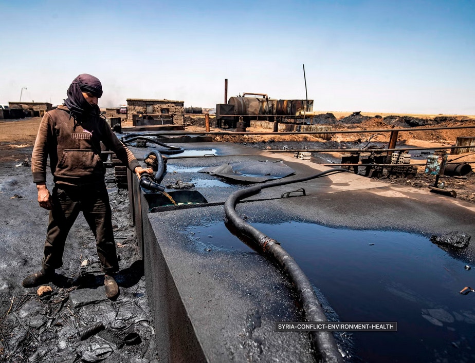
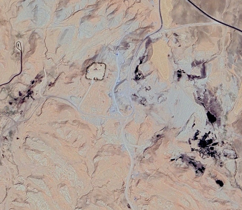
I have not been able to locate the Rmelan oilfields with certainty. I have located oilfields near Rmelan, about 10-11 miles northeast of the town. This photo, credited to Delil Souleiman/Getty Images, tipped me off. The caption reads: “A man distills crude oil at a makeshift refinery near Rmelan, a major hub of Syria's oil industry.”
This caused me to conclude, “Look for the black stuff” in the Google Earth imagery. This image shows what I believe to be part of the Rmelan oilfields.
There is a treasure trove of Syrian oilfield-related photos online, most of which were taken by Delil Souleiman/Getty Images. I suggest you browse through them. They will give you a terrific perspective.
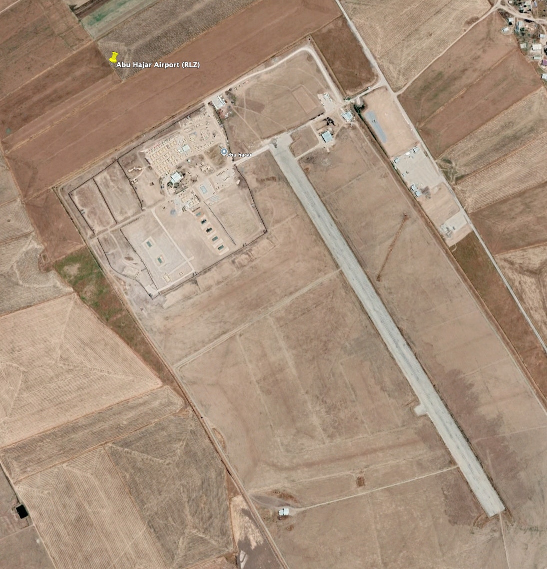
My main attraction is not the oilfields but the Abu Hajar Airport, about seven miles southeast of Rmelan town. I believe US military forces use this airport, which is an important logistics hub for US forces in northeastern Syria.
My assessment of Google Earth imagery is that its runway is 4,000 feet long, making it unsuitable for jet fighters. However, it is suitable for prop-driven transports and, if the following report is accurate, perhaps even larger jet transports such as the C-17.
Ahed Al Hendi and Carla Babb reported for VOA in March 2017,
“Syrian Kurds built an airbase last year on farmland known as Abu Hajar airport in the Rmelan area and nearly doubled the runway length to allow for delivery of cargo initially.”
I have seen this airport called the Rmelen Landing Zone, or RLZ. According to Wikipedia, the US planned to extend it to 8,000 ft. in 2016.
I have also seen many recent news reports from the Near East press asserting that US heavy transports, such as the C-17, were landing at the Kharab al-Jir airbase. I labored to locate this base to no avail. However, quite by luck, I ran across a release in October 2023 from The Syrian Observer that referred to Abu Hajar Airport as near Kharab al-Jir's village. For the moment, I concluded that some reporters call the Abu Hajar Airport “Kharab al-Jir.”
Two more clips about Rmelan.
Co-op Mesopotamia has said Rmelan is now “the Jazira headquarters of the Movement for a Democratic Society, or TEV-DEM, Rojava’s (AANES’s) coalition government.”
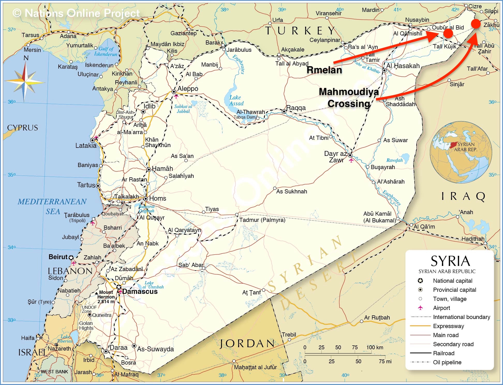
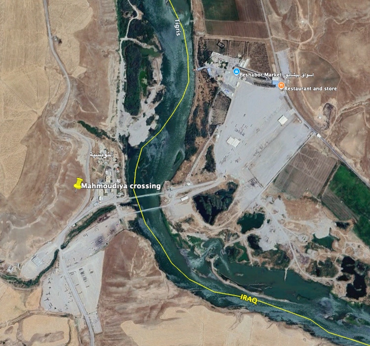
The Syrian Observer said in January 2022 that the US-SDF installed a refinery in the Rmelan fields. Syrians have alleged that US forces in this northeastern sector of Syria have been transporting Syrian oil to Iraq through the Mahmoudiya Crossing. Many Near East news outlets make this assertion. The crossing is about 12 miles as the crow flies northeast of the oilfields.
Al-Malikiyah (Deir): Al-Malikiyah (Deir) is located in the northeast corner of Syria. Wikipedia has said that the SDF took Al-Malikiyah in 2012 after considerable fighting with Syrian government forces. The US uses a base near the town of Robariye, which is about five miles southwest of Mailikiyah. I have seen multiple Near East press reports saying US forces have been attacked at “Robariye.” There is a runway I have measured to be about 4,000 ft., less than a mile east of Robariye and connected to the village by a road. I have read a few reports that US patrols have stopped in the village to talk to the locals, so it looks like US forces operate in this area. The village is only five miles southeast of the border with Turkey. I have concluded that this runway area is the Al-Malikiyah base.
The Cradle reported in October 2022 that “The Al-Malikiyah base was established by the US in 2021 near the Turkiye-Syria-Iraq border to facilitate the theft of Syrian oil.” Al-Malikiyah is about 10 miles northwest of the Mahmoudiya Crossing into Iraq. Many Near East news reports accuse the US of stealing Syrian oil and transporting it to Iraq. I suspect there is some truth to that.
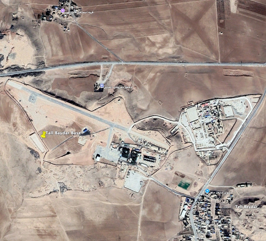
Tal Baydar is about 16 miles northwest of Hassaka city. It is located about 18 miles south of the border with Turkey. It is a small village, but on its northwest side, there is a paved 3,000-foot runway, and a separate compound is connected to it by road. The village is also near the M4 Highway, providing excellent US patrol access. I’ll note that there is another runway about four miles southwest of Tal Baydar. This runway appears unpaved in a 2022 Google Earth image. Interestingly, it is about 5,000 feet in length.
It is worth noting that in October 2023, a USAF F-16 fighter shot down a Turkish drone flying over the Tal Baydar base. The US claimed the drone was flying inside a “declared US-restricted operating zone.” The drone was said to be armed with air-to-ground missiles, which the US considered a threat.
Turkey, of course, is a NATO ally, “sort of.” The US feels obliged to protect its troops on the ground yet, at the same time, says it recognizes Turkey’s security concerns with the Kurds (SDF). That looks like the penultimate “waffle” to me.
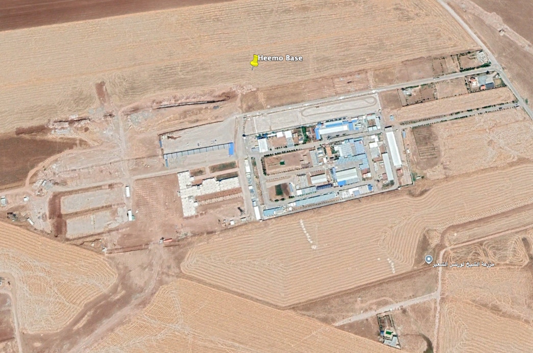
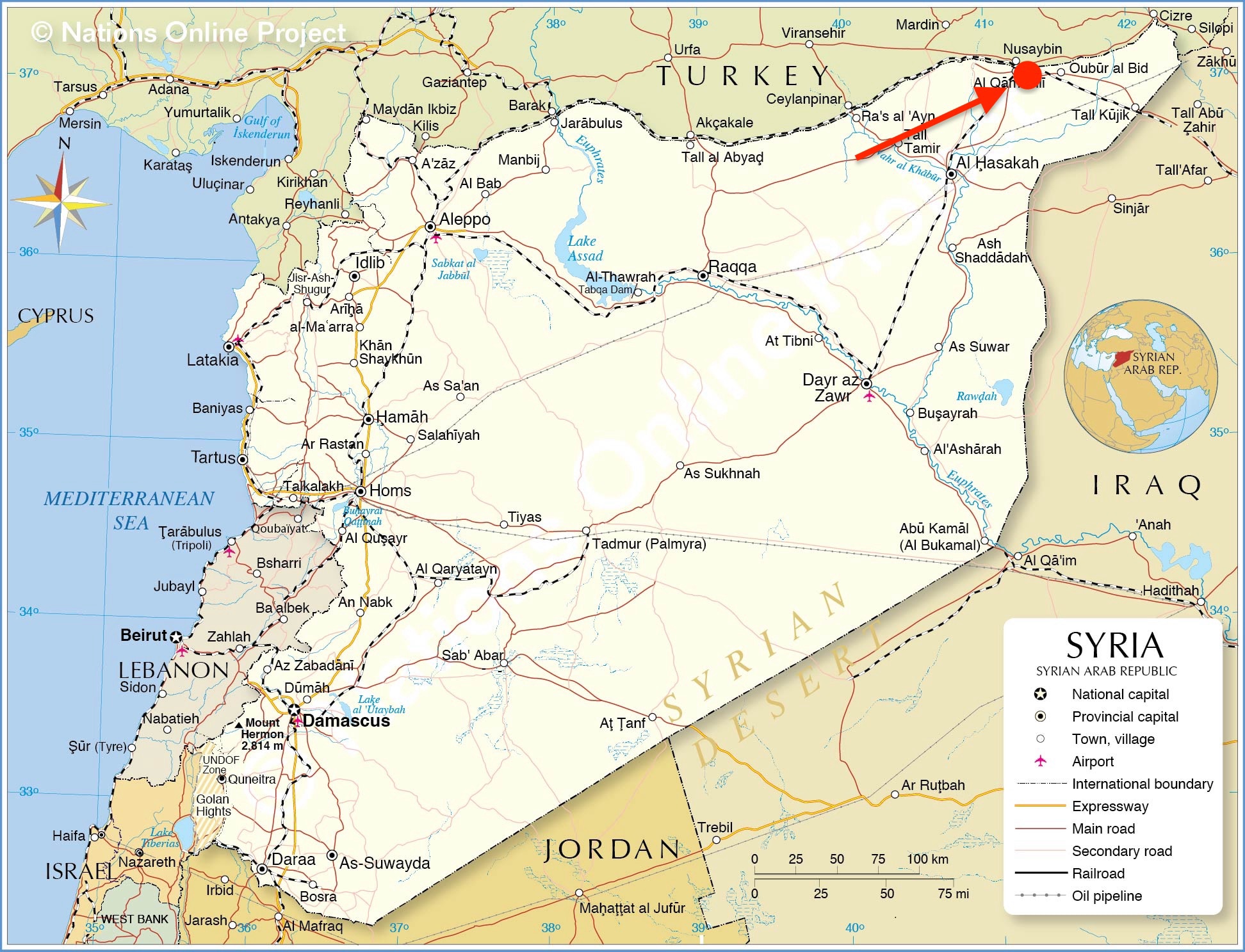
The Heemo base is four kilometers west of Al-Qamishli, near the village of Heemo. The Middle East Media Research Institute (MEMRI) said in September 2019 that the US base near the Heemo village was established in 2018 and “provides all kinds of administrative and technical support to the Syrian Democratic Forces and its civilian administration.”
The Cradle reported in January 2024 that the “Hemo base is considered one of the most vital US occupation bases in Syria.” The Syrian Observer reported, "The Hemo base is of strategic importance, housing training centers for SDF special forces and a US intelligence office responsible for overseeing all US bases in the region.” Al Mayadeen reported in January 2024 that the base has increased its troop strength to 350 troops.”
Notwithstanding all that, these three reporting stations said US troops evacuated the Heemo base on January 16, 2024, and moved to Tal Baydar. I suspect that is true since Tal Baydar is a more formidable installation, and Heemo had been enduring many attacks. Multiple Near East news sources said the US left the Heemo base on January 16, 2024. It’s not much of a base for repelling enemy attacks.
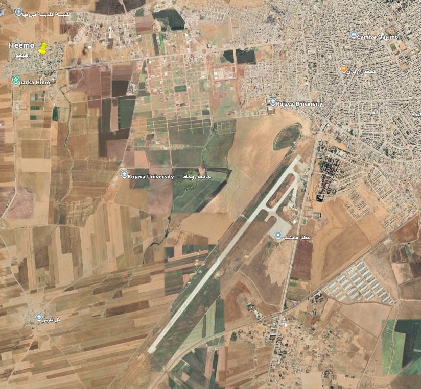
I became most interested in the city of Al-Qamishli, which is on the Turkish border and near the Heemo base.
The city is said to be the de facto capital of the Jazira region of the AANES. Indeed, the Rojava (AANES) University is located here. The city is located in the northeast of Syria, which has been a bastion of US-SDF control. Its population is about 200,000, so it’s sizeable.
The runway on its southwest side is 11,830 feet long, which is impressive. The average length of runways at major commercial airports is between 8,000 and 13,000 feet.
Wikipedia has said the airport was closed in 2015 because of the civil war. In January 2016, the Russians sent a team to the Qamishli airport to assess whether to build a Russian air base there. Recall that the Russians intervened militarily in Syria’s civil war in 2015 to support Assad. Jennifer Griffin reported for Fox News that a senior US official told her, “This is another example of the Russians [messing] with the Turks.” Griffin commented, “Russia and Syria’s Kurds have a common enemy in Turkey and make natural allies.” Keep that in mind.
It seems the Russians were more than just messing with Turkey. They were also messing with the US. To start, look at Qamishli’s location in far northeast Syria. It is close to Turkey but also in the heart of the US-SDF zone of interest in the Hassaka Governorate.
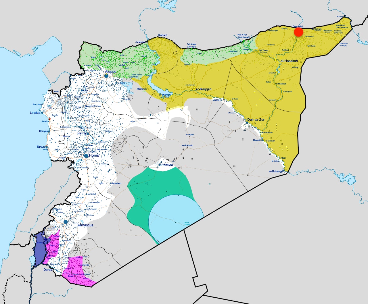
The Russians conducted several thousand air attacks against anti-Assad forces. This map shows that most Russian military action was confined to western Syria, shown in white. The SDF-US held the northeast, shown in yellow. The red dot shows the location of Qamishli in the heart of the US-SDF-held northeast. The Russians conducted some attacks along the Euphrates and in the area of Palmyra in central Syria, but the focus of their attacks has been in the west.
One can conclude that Russia’s obtaining use of the Qamishli airport would threaten the US-SDF posture in the northeast region of Syria.
The US and Turkey made arrangements for the US to withdraw from Qamishli, and they did so in October 2019, leaving the city under SDF control. In November 2019, the Russians took control of the airport, intending to use it primarily for helicopters, transport, and air defense.
Two relevant events that occurred in late 2019 bear on this arrangement.
First, on October 6, 2019, President Trump announced his decision to withdraw U.S. troops from northeastern Syria. The decision reportedly resulted from a phone conversation with Turkey’s President Erdogan, who sought to establish a buffer zone south of its border with Syria.
Second, Turkey launched “Operation Peace Spring,” targeted at the SDF, in October 2019.
I do not know what President Trump and President Erdogan discussed in their telephone call. However, I believe Erdogan hoped to expel the SDF from the border area south of a 20-mile safe zone and urged the US to get out of the way.
The Center for American Progress opined,
“Abandoned by the United States and facing attacks by Turkey and its proxies, the SDF pivoted to their protector of last resort: the Assad regime and its Russian backers.
“The SDF invited Syrian and Russian forces to move swiftly into disputed areas … The Syrian regime and Russia raced forces into key positions to stake their claim and establish effective control.
“This madcap race to carve up the Northeast has resulted in a patchwork of effective control, with the region split between the Assad regime and the Russians, Turkey and its proxies, and the remnants of the SDF, with varying levels of regime cooperation.”
The European Parliament saw this development as “Turkey’s further strategic decoupling” from the EU and the United States.” It said that Erdogan had been reinforcing his ties to Russia since 2016 and hoped Turkey and Russia could fill the void left by the US.
The Trump decision caused a political uproar in the US. Expert observers of events in Syria asserted that the US was surrendering its influence and power to Turkey, Russia, and even Iran. US forces indeed pulled out of areas near the Turkish border, but Trump’s advisors convinced him to put them back into the Euphrates River Valley to protect the oilfields.
US commanders redistributed their ground forces to the oilfield areas in Deir Ezzor, mainly to Conoco and Green Village. General Milley, USA, CJCS, said US forces would be split between the Euphrates Valley and al Tanf in the south, which will be addressed in the next section. The US force level in Syria was said to be 900 when it was all finished.
In December 2024, following the fall of Assad, another shoe dropped. Israeli fighter aircraft attacked the Qamishli airport on December 9, 2024, the day after rebel HTS forces stormed Damascus. Assad left in the early morning hours of December 9, bound for Russia.
Delil Souleiman reported for AFP/Getty Images that the attacks were targeted at shipments of weapons that belonged to the Assad government. Three days after the Israeli attack, December 12, 2024, Souleiman photographed a “Russian Air Force Mil Mi-8 military transport helicopter and gunship” at the Russian Qamishli airbase, along with many Russian trucks.
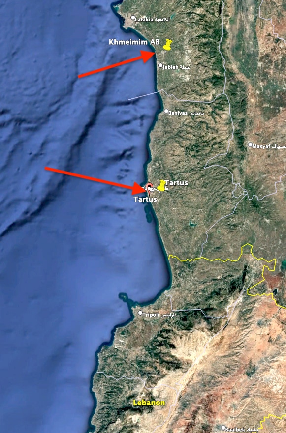
Ukrainian intelligence agencies said the Russians left Syria’s interior in December 2024, including Qamishli, and remained only at Hmeimim Air Base and the Port of Tartus. The Institute for the Study of War (ISW) could not confirm this. As an aside, Ukraine has had an interest in Syria and sent its foreign minister to visit the new post-Assad regime in Damascus. It is a market for Ukrainian grain, a place the Russians felt they had to leave, and Ukraine hopes to convince the new rulers to evict the Russians altogether.
On January 5, 2025, Souleiman photographed American soldiers patrolling the city, which surprised me. Souleiman also photographed a power station in Qamishli that had been struck on or about January 5, 2025, by a series of Turkish drone attacks against the city.
Reports in late December 2024 indicated Turkish-backed Syrian rebels and the SDF were in battle. So a question left open is why US troops in Qamshli were in the city on January 5, 2025, after leaving in 2019.
Raqqa Governorate
IS took control of the Raqqa Governorate in late 2013. It was the first governorate to fall to the IS. IS declared Raqqa to be the capital of its caliphate in 2014. The SDF launched an offensive in northern Raqqa Governorate in 2016 and took control in 2017. CJTF air power provided support. CENTCOM commented,
“Raqqa became a magnet for foreign terrorists. Residents were forced to live under a brutal regime that routinely carried out public executions, extortions billed as ‘taxation’ and forced conscriptions. ISIS used its three-plus year occupation to convert Raqqa into a fortified military prison.”
US forces left the governorate in 2019, Turkish forces moved in, and the Russians did as well. The governorate was occupied by the Assad regime, the SDF, Russia, and Turkey, with the IS and US in and out, indeed a mess. The European Union Agency for Asylum has described all these “comings and goings,” and I applaud its work. It’s enough to convert your headache to a migraine.
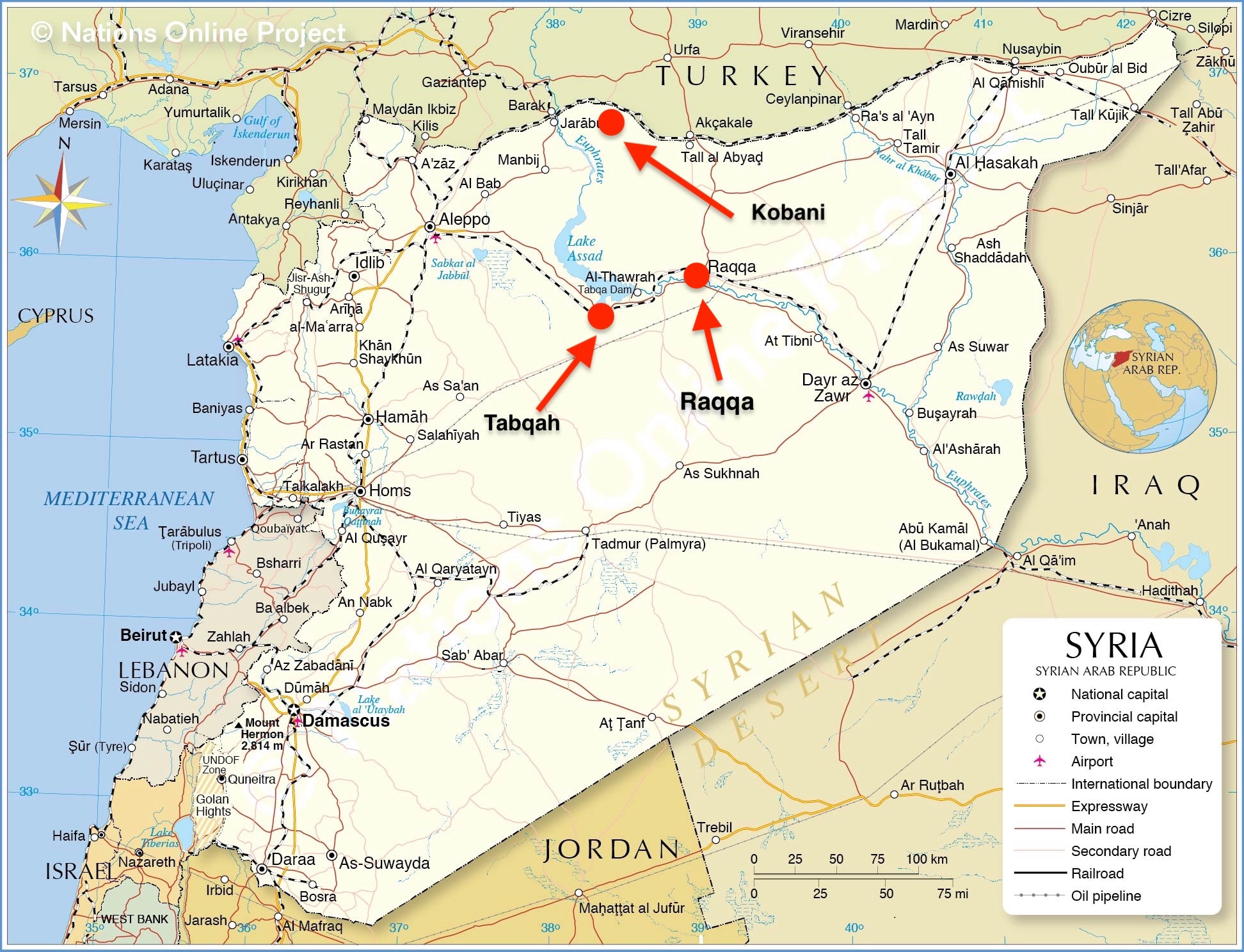
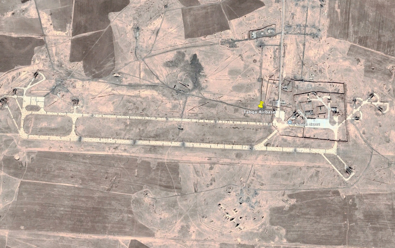
Tabqah Airfield: It is about six miles south of Tabqah city and 28 southwest of Raqqa. IS fighters took control of the airfield in 2014. In March 2017, Ahed Al Hendi and Carla Babb reported that American engineers and crews worked to repair the airfield. They said,
“U.S. General Carlton Everhart, commander of the Air Force's Air Mobility Command, told VOA that his men had airlifted SDF forces behind IS lines to allow them to launch the attack that captured the airfield … The capture of Tabqa airfield comes as the U.S.-led coalition has been quietly increasing its aerial capability in northern Syria to include more landing areas and bases for taking the fight to IS.”
However, Russian and Assad regime forces took the Tabqa dam in 2019 as US forces withdrew. I believe US forces returned to Tabqa airfield in 2022, but I cannot confirm this.
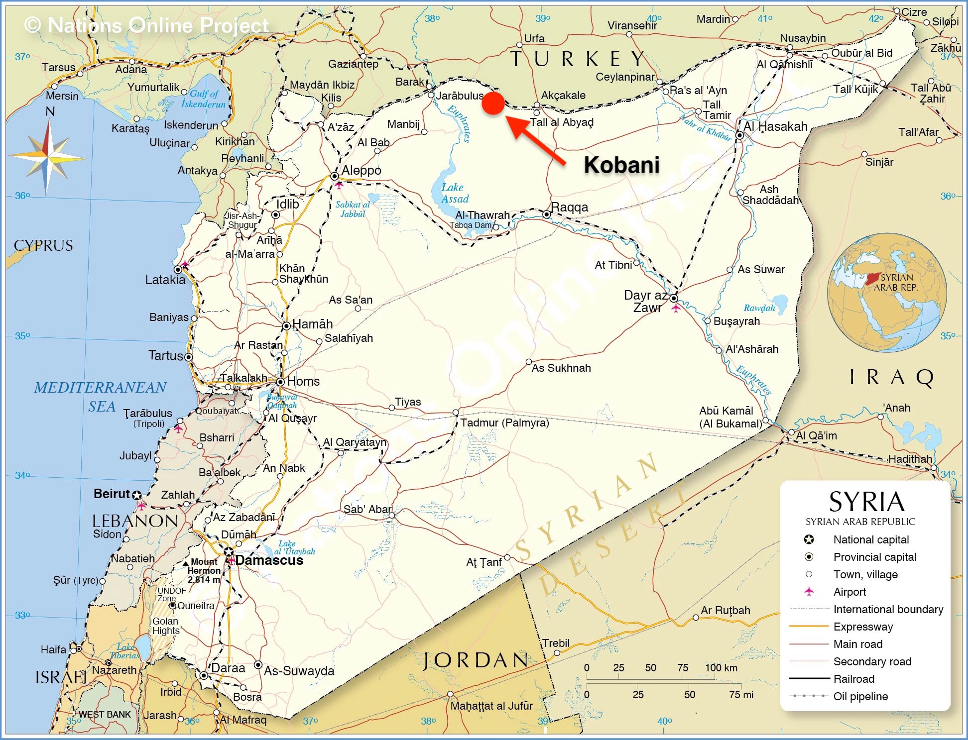
Kobani base: The Kobani story will rattle your cage. It lies on the border with Turkey. Wikipedia has said the Kurd YPG militia took control of the city in 2012. The WarZone in October 2019 implied the US established a base at Kobani in 2013-2014. As has been the case in so many instances, the Kobani story is mind-boggling.
In 2014, IS launched a major offensive against the Kobani region and captured most of it. It was thought that IS wanted Kobani in part because they could use routes through Turkey to funnel more fighters into Syria, and they could obtain a strategic border crossing between Syria and Turkey. Kobani was also part of the IS effort to control the petroleum industry in Syria; that is, sell Syrian oil in Turkey at rock-bottom prices to fund IS.
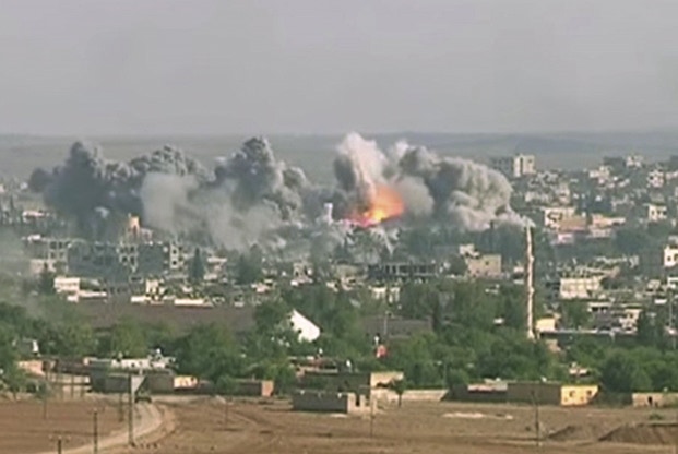
The CJTF bombed IS targets in and around Kobani from September 2014 through January 2015 in an 112-day siege. This photo shows “A coalition air strike on an ISIS target in Kobani in October 2014. The city was also known as the “Kurdish Alamo.”
General Martin Dempsey, USA, CJCS, said in October 2014 that he was fearful Kobani would fall. Rand Corp. opined that IS had 4,000 fighters in Kobani.
General John Allen, USMC, President Obama’s coordinator for international efforts against IS, said,
“ISIL (another acronym for IS) continues to pour fighters into the process. And as they pour fighters into the process, we are going to continue to bomb them, we are going to continue to interdict their supply lines, we are going to continue to disrupt command and control, and at the same time, do what we can to support the defenders.”
As IS sent in more and more fighters and incurred more and more casualties, its attempt to control Kobani became a publicity war for both sides. Lina Khatib suggested that IS had tended to wage psychological warfare when its military situation was not going well.
The US-led coalition broke the siege in 2015. The intensity of the American effort to defend Kobani marked a turning point for the US. In short, the US was, from this point forward, committed to fighting in Syria and supporting the SDF. The US made Kobani the headquarters for US-led coalition operations to retake Raqqa. The Kobani airport is about 17 miles south of the city. A report from VOA said US forces built the airport from scratch.
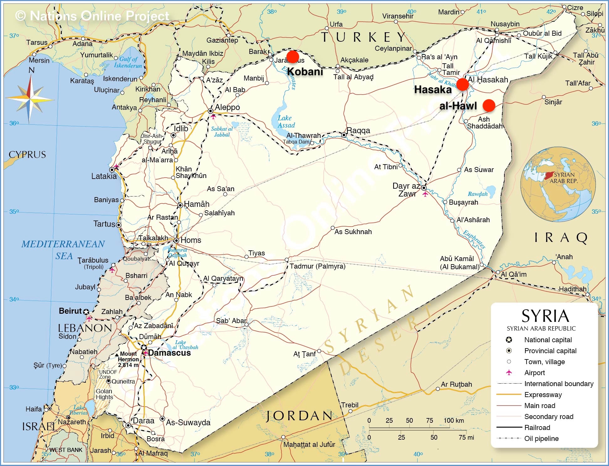
Following the recapture of Kobani, CJTF struck against Hasaka on the Euphrates River about 90 miles to the east-southeast. They then moved to al-Hawl on the border with Iraq.
Despite all this, Kobani continued to be a juggling ball. In October 2019, US forces withdrew from Kobani after President Trump decided to leave.
Once again, the SDF was left in control of the city.
President Assad’s Syrian Army then entered the city, seemingly to prevent Turkey from creating a buffer zone south of its border with Syria. The SDF seemed to agree with the Syrian Army’s move to protect itself from the Turkish military. According to Wikipedia, Russian military police collaborated with the Syrian Army in Kobani.
In December 2024, Turkish proxies and the Turkish Air Force launched an offensive to take Kobani from the SDF. However, I have seen a report that the US stepped up its patrols in Kobani to support the SDF in its trials and tribulations with Turkey. In January 2025, reports were coming from locals in Syria taking videos showing heavy trucks carrying the American flag escorted by US forces moving equipment and supplies toward the Kobani city center. Journalists concluded that the US was setting up a base at Kobani.
That said, Pentagon Spokesperson Sabrina Singh told reporters in January 2025, “When it comes to US forces in Kobani, there's no plan or intent right now to set up any base. I'm not sure where those reports are coming from.” I think the operative word is “now.” My gut says US forces had already set up shop.
Click to zoom graphic-photo