DUTY, HONOR, COURAGE, RESILIANCE
Talking Proud: Service & Sacrifice
Lima Site 85, Laos: Exceptional Courage Against Impossible Odds
The CIA Base Lima 85
The Office of the Historian for the US State Department has written that the Eisenhower Administration viewed Laos as the “cork in the bottle” in Southeast Asia. How goes Laos, so goes all of Southeast Asia. Laos was not ready for independence in 1954. It was very fragile. The US leadership did not understand what the people of Southeast Asia wanted. The fear in the US was communism. Having had a Eurocentric foreign policy, the US bowed to French colonizers and enabled France to come back to the region following WWII.
CIA began operating in Laos in the 1950s, providing military assistance to the RLG, hoping to strengthen the RLA and RLAF, hoping to ward off communism. It used its covert airline, Air America, to provide hardware and other support.
The CIA created a series of numbered landing sites called the Lima Sites. These Lima Sites were usually small dirt landing strips, though some were paved. The NVA used the Ho Chi Minh Trail to support its war in the RVN, a civil war. The US CIA built landing sites to help the RLG during the Laotian Civil War.
Supporting the RLA was problematic. It was an outgrowth of French colonization. It was a lightly armed militia designed to provide static defense of populated areas. It was ill-equipped to fend off the well-equipped, well-trained, and highly maneuverable NVA and Pathet Lao.
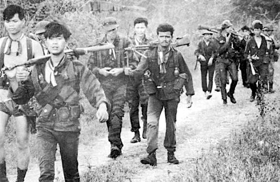
The CIA had been involved with the Thai Border Patrol Police, known as the PARU. It became involved with border security and counterinsurgency. Under CIA tutelage, it occasionally crossed its border with Laos to hunt for insurgents. An idea evolved that the CIA ought to create an army employing indigenous Hmong ethnic people in Laos to fight against the communists, the Pathet Lao insurgents, and the NVA.
An RLA officer and ethnic Hmong named Vang Pao attracted the CIA’s attention. He led this new CIA Hmong Army in northern Laos. His headquarters was at LS-20A, Long Tieng, a major airbase in Laos operated by the CIA.
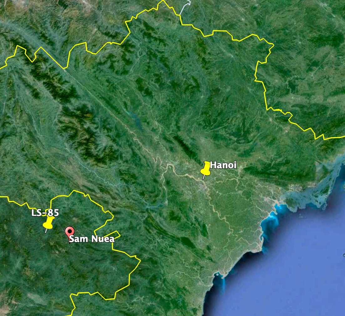
Three Laotian provinces border with NVN in the northeast: Phongsali, Housphan, and Louangphrabang between the two. Louangphrabang Province hosted the city of Luang Prabang, the ancient capital of Laos and the seat of the RLG. The Geneva Conference of 1954, among other things, allowed the Pathet Lao to control the other two provinces. Phongsali and Houaphan. This was a feather in the cap for the NVN and NVA.
Over time, Houaphanh Province, known in some circles as Xam Nua Province, would become the heart of enemy NVA territory. It offered the NVA security insurance and a perfect location to extend its operations in Laos and support Pathet Lao advances throughout northern Laos. Sam Neua, the provincial capital, became the Pathet Lao headquarters.
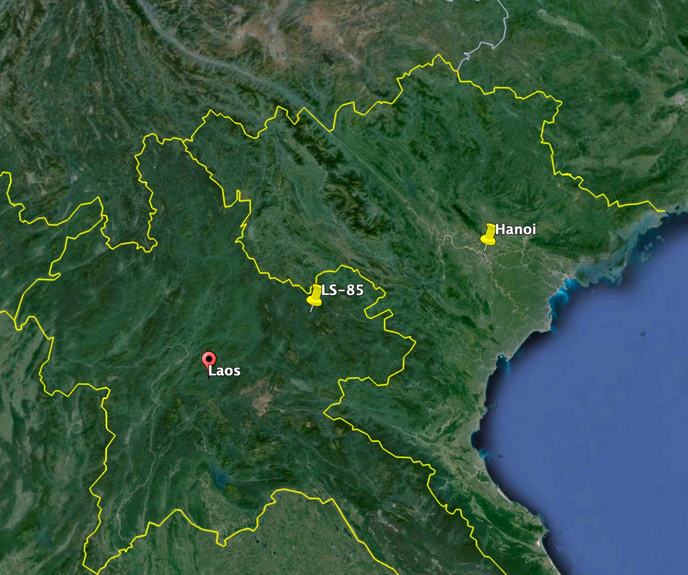
During the colonial period, the French had a military site in Houaphanh Province at Phou Pha Thi Mountain, Phathi. The NVA seized this French site in 1962. The CIA led the Hmong Army to recapture the area, and the CIA established an unsophisticated airstrip there in 1966. It was named LS-85. It was in the heart of enemy territory. The NVA was strong in this area. LS-85 was 21 miles west of Sam Neua City.
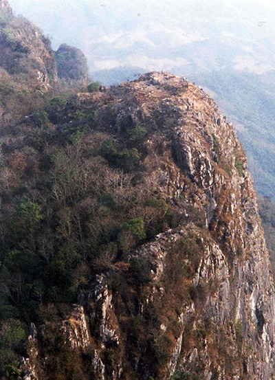
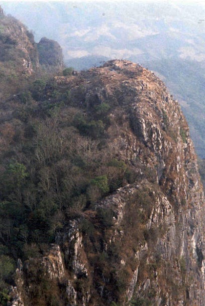
Phathi Mountain’s elevation was 5,860 ft. One geographic description of it goes like this:
"It is the highest peak in the region. All four sides of the karst are sheer cliffs between 50 and 200 meters high. From about mid-way between the base and the summit of the mountain, the sides were formed by 75-degree to 80-degree cliffs and, in some spots, 85-degree to 90-degree cliffs. The peak of Phathi Mountain is at least 3-4 kilometers from the surrounding peaks.”
John T. Correll, writing “The Fall of Lima Site 85” for the April 2006 edition of Air Force Magazine, said,
“The drop on three sides (of the mountain) was nearly vertical.” The fourth side, the mountain's southeastern side, was a shallower slope that faded into a plain.
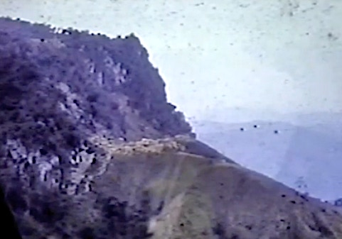
This photo, taken by John Tarn, an Air America UH-1 helicopter pilot (1965-1968), shows the more shallow slope of LS-85 and then the rise up to the mountaintop. There is a Hmong village there where the shallow slope meets the cliff.
Not only was Phathi high, it was isolated. The terrain was rugged, with numerous caves and dense mountain forests throughout most surrounding areas.
Phathi was about 15 miles from the NVN border and about 140 miles southwest of Hanoi. It had a virtual line-of-sight view of Hanoi and its surroundings.
The CIA established a command site down the hill from the Phathi summit, near the village on the southeast part of the ridge that was a shallower slope.
CIA paramilitary and Hmong fighters used this location as a staging base to fight against Pathet Lao and NVA forces in the province and to communicate orders to Hmong forces in the field. The landing strip (landing zone—LZ) was about 600-700 ft. in length and located about 200 yards down this slope. Phathi village was also located on this slope. Many of the Hmong fighters lived there with their families.
The USAF saw great advantage in using LS-85 to support its bombing operations deep in northern NVN. The site would experience mission expansions and attract growing NVA attention.
Click to zoom graphic-photo